Where Footpaths Meet the Tide

Today we step into Rising Seas and Changing Tides: How Climate Change Threatens Cornwall’s Tidal Crossings, exploring the fragile, much‑loved paths that appear and vanish with the moon. From the granite causeway to St Michael’s Mount to fleeting sandbars and seasonal bridges, we’ll uncover science, stories, and solutions. Walk with us through memory and evidence, and share your experiences so we can protect safe crossings and cherished moments for the next generation.

St Michael’s Mount: Stones Between Storms

Cobble by cobble, the causeway between Marazion and the island tells a story older than any visitor queue. Its stones gleam with salt and centuries of footsteps, open for hours around low tide, then swallowed by glittering water. Families time crossings with chalked tide tables; staff ferry supplies when swells rise. Recently, higher baseline sea levels and punchier storms have reduced predictable windows, complicating staffing, deliveries, and ambulatory access, while increasing reliance on boats that can be grounded by waves or winds.

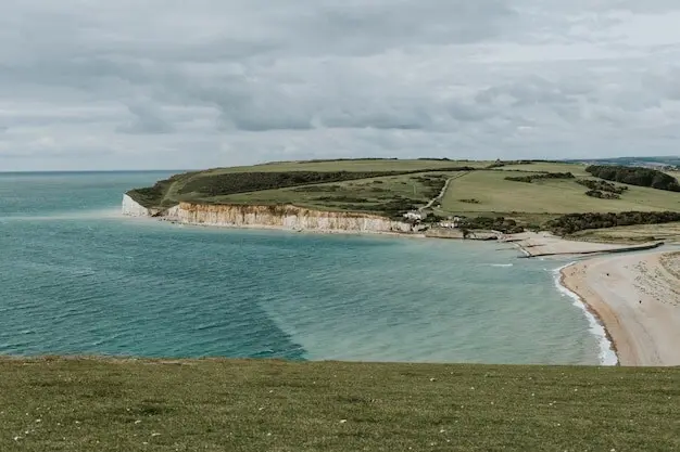
The River Gannel and Seasonal Bridges

Near Newquay, the Gannel’s channels slice sands into shifting puzzle pieces. A seasonal footbridge appears to help walkers avoid wading the cold, fast tide, yet even with planks in place, timing matters. Locals recount childhood summers learning to read rippling channels like a book, watching gulls lift as the flood arrives. Warmer oceans and heavier rains are altering freshwater pulses and tidal heights together, complicating simple rules of thumb once passed from grandparents to grandchildren on breezy evenings.

The Newlyn Tide Gauge Story

Humming quietly since 1915, the Newlyn tide gauge has become a guardian of coastal truth for Britain, anchoring maps, forecasts, and engineering. Its long record shows rising relative sea level, once nearly imperceptible, now increasingly evident in overtopping events and nuisance flooding. Technicians verify sensors, epidemiologists of water study patterns, and planners translate lines into budgets. Each year of data narrows uncertainty, while lived experience—soaked promenades, shuttered quays, shortened crossing times—translates numbers into decisions families make on grey, gusty mornings.

A Higher Baseline for the Same Tide

Imagine lifting the whole sea by a hand’s breadth; every high tide now climbs that much farther, and every storm rides in on a raised platform. The astronomical cycle still swings, yet the crest more frequently leaps the familiar edge. For tidal crossings, that means earlier submergence and later emergence, squeezing safe windows. When extra rainfall swells rivers on the ebb, the meeting of fresh and salt can further complicate footing, where silt softens, channels veer, and previously firm paths betray a boot.

Timing Crossings With Care

Golden rules endure: check official tide times, add a safety buffer, watch the water’s edge rather than your watch, and never race the flood. Locals teach newcomers to judge by seaweed gleam and channel sparkle. Yet higher water can surprise, shortening routes unexpectedly. RNLI volunteers recall assisting walkers stranded by ten eager minutes. Clear boards at access points, multilingual cues, and live digital updates reduce confusion. Sharing real-time photos or webcams can turn passive advice into vivid, persuasive guidance that saves wet, frightened steps.

Economic Ripples for Local Business

When openings shrink, shops and cafes near crossings feel the pinch. Deliveries bunch awkwardly; customers hesitate; tour slots evaporate with a fresh forecast. Heritage staff pivot from welcoming to water-watching. Innovative responses help: flexible ticketing tied to live conditions, pop-up offerings when paths reopen, partnerships with boat operators sharing capacity data. Grants for storage, resilient flooring, or backup power reduce downtime after splash events. Every minute reclaimed through planning or communication can preserve livelihoods without pushing visitor pressure onto fragile intertidal habitats.

Community Routines at the Water’s Edge

From Sunday strolls to after-school dashes, people structure time around tides without even noticing. Choir rehearsals shift by weeks, dog walkers learn the sand’s firmness, and cyclists map wind shadows. As sea levels rise, routines fray: familiar shortcuts vanish earlier, and darkness meets higher water more often in winter. Communities respond creatively—shared lifts, neighborly check-ins, laminated local guides in village halls. These small agreements, carried by trust and patience, stitch resilience into everyday life as predictability thins along beloved shorelines.

Engineering With Character: Blending Hard Edges and Living Shores

Adaptation works best when it respects Cornwall’s identity. Solutions must keep people safe without erasing heritage charm or crushing intertidal life. Elevated or permeable causeways, discreet handrails, textured non-slip stones, and better lighting can extend safe windows. Living shorelines—saltmarsh fringes, eelgrass beds, dunes—absorb energy and nurture wildlife. Designs should welcome storms to pass through rather than batter a single line. Above all, flexible pathways ensure today’s fix can evolve as seas rise, safeguarding both access and beauty.

Raising and Perforating Causeways

Rather than a single, taller wall, consider gently lifted paths with culverts, slots, or voids allowing tidal exchange and sediment flow. Such designs reduce scouring, preserve habitats, and accommodate incremental upgrades as projections update. Roughened, locally sourced stone echoes historic textures while improving grip. Tactile paving alerts distracted walkers without spoiling views. Embedded sensors can report overtopping minutes before it occurs, triggering signs or messages. When carefully co-designed with heritage bodies and ecologists, these modern touches feel like respectful evolutions, not intrusions.

Flexible, Tidal-Safe Transport Options

Where water closes the walkway, nimble alternatives can step in: electric shuttle boats with shallow drafts, coordinated with real-time tide and wind data; e-cargo trikes bridging gaps for deliveries; sheltered waiting nooks with accurate countdowns. Ticketing that auto-adjusts for conditions builds trust. Training skippers and staff in accessibility ensures prams, wheelchairs, and shopping bags move smoothly. When redundancy is designed in—path or boat, whichever is safer—communities stop gambling with weather and start managing it, keeping daily life humane and dependable.

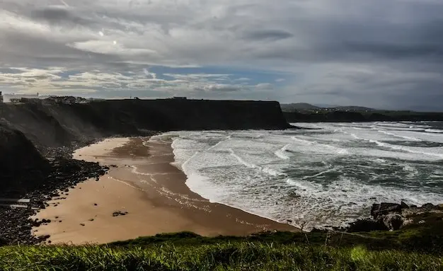
Nature-Based Defences and Intertidal Allies

Healthy dunes, saltmarsh tongues, and eelgrass meadows dampen waves before they slap stone. Projects near estuaries like Hayle can create room for marsh migration by setting back hard edges, while fencing and boardwalks guide feet away from vulnerable plants. Coir rolls, brushwood, and shingle recharge blend with scenery and can be refreshed as conditions evolve. Monitoring invertebrates and water clarity provides quick feedback. When people witness wildlife flourishing alongside safer crossings, support for gentle, living solutions grows stronger than any concrete promise.

Keeper of the Causeway

A longtime island worker recalls memorizing stone patterns like friends’ faces, knowing exactly which cobble points true when the fog drifts in. In recent years, their notebook shows more days when boats replace boots, and more minutes shaved from comfortable crossings. They now text photos to staff groups, flagging early closure, and lobby for discreet lighting that respects dark skies. Their pride is palpable: not resisting change, but guiding it, so visitors still feel wonder while crews feel safe.

Mousehole Mornings at the Slip

A fisher describes launch windows pinched by higher tides meeting onshore winds. The old routine—coffee, net check, gentle push—now competes with edgier swell. They favor small adaptations: a sturdier winch, shared tide-wind notes, reflective markers along the slickest edge. What they fear most is complacency, not weather. They welcome sensible upgrades that do not sterilize the quay, and offer to test alert systems, because a good morning’s catch should never be traded for an avoidable stumble into dark water.

Get Involved: Observe, Share, Support, and Stay Connected

Everyone can help keep these crossings meaningful and safe. Observation builds evidence; conversation spreads caution; small donations leverage larger grants. Share tide photos, note overtopping times, and record wind conditions to refine guidance. Subscribe for local alerts and in-depth features, add your stories in the comments, and invite neighbors to compare notes over tea. The more eyes and voices we bring to the edge, the stronger our collective footing becomes as the ocean quietly rises beneath familiar skies.
Lentozeravirokarofarivelto
Privacy Overview

This website uses cookies so that we can provide you with the best user experience possible. Cookie information is stored in your browser and performs functions such as recognising you when you return to our website and helping our team to understand which sections of the website you find most interesting and useful.